Map settings change how the analysis is displayed. They do not change the site’s location or catchment figures. On a smaller screen, open Analysis settings to find the map-style control.

Change the map style

  1. Open Map style in the workspace header.
  2. Choose the style you want to use.
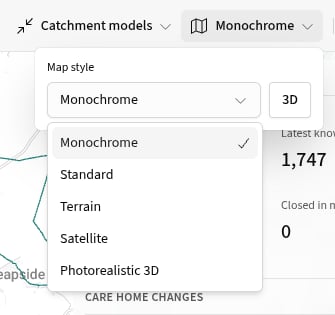
Map style menu showing Monochrome, Standard, Terrain, Satellite and Photorealistic 3D, alongside the 3D button. For Monochrome, Standard, Terrain and Satellite, select 3D to tilt the map. Select it again to return to a flat map. Photorealistic 3D opens directly in three dimensions.

Show or hide layers

  1. Open Layers on the right of the workspace.
  2. Use a layer’s switch to show or hide it.
  3. Open Show style controls to change the options available for that layer.
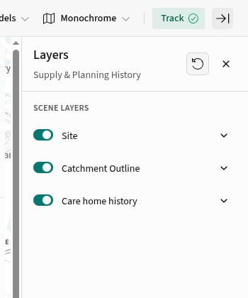
Layers panel showing switches for Site, Catchment Outline and Care home history, with the reset control above. The available layers depend on the current analysis view. They can include the site, catchment, care homes, planning records and a related built-up area. Style controls also vary by layer and can include opacity, colour or labels.

Nearby places

Points of interest (POIs) are available in saved site analysis. Each type shows the nearest places to the site, up to the configured number and search radius. They are not available in area or built-up-area analysis and do not represent complete catchment coverage. POI collections group places by type, with the nearest places first in each table. The tables sit side by side when space allows and stack in narrower panels. Select a type to filter both the table and its map layer. Select All to show the collection again. Distances in the table are straight-line distances from the site, shown in miles. Select a place in the table or on the map to see its address and route. Choose Walking or Driving to change the journey calculation. Where available, Open in Google Maps opens the provider’s place record. Select Refresh to update nearby places. After a refresh, the button shows the remaining wait before you can refresh again. If a type cannot refresh, previously loaded results remain visible where available, alongside the error.

Restore the view defaults

Select Reset map at the top of Layers, then confirm the reset. This restores the current view’s saved map style, layer order and visibility. It does not change the site or catchment. Your map choices stay with the analysis workspace. When a PDF includes the current map, it uses these choices. Next, export the analysis.